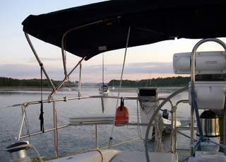
August 1, 2008 -- The Bustards to Wright's Marina in Britt (Bying Inlet)
We didn't stay long in the Bustards because our holding tank was getting full; but we faced a dilemma. We didn't have detailed charts for our trip from the Bustards to Britt and we didn't want to go back east. We finally decided that the large scale chart that we had would suffice and, since we know how to navigate with paper and pencil, it was a go. It really wasn't that bad and the route into Britt was well buoyed (freighters call at Britt, actually Byng Inlet across the river). The winds even cooperated and we had a great sail.
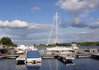
We pumped out and in, settled into our slip and started to explore Britt. We talked to Whitecapper who was out of the water getting a new prop. She hit a rock on the way into Thomas Bay and made it to Britt to get hauled (one of the problems with wilderness cruising is that services are few and far between).
 Everybody said that we had to eat out at the Little Britt Inn. The upper level is a fine dining experience and the lower level an English Pub. People recommended that we try the lower level (are they trying to tell us something?) We called Jim, the proprietor, for a ride but he was busy so Kari Wright gave us a ride in her pickup truck (her son had to ride in the back) and said that she would pick us up if the Inn was full. It wasn't and we had a great meal of fish and chips with a local brew. Jim was even entertaining in a curmudgeonly way. We walked back to the marina and called it a night.
August 4 - 10, 2008 -- Bad River
Bad River is a great anchorage to spend a lot of time in. It is well protected, large enough to have a lot of boats, miles of shoreline to explore and good fishing. The only problem is that it is a popular anchorage with a lot of boats dropping by. It's hard to describe everything we did during the week that we spent there. We even siphoned a couple of gallons of diesel out of our tank to give to a sailboat that was running out on their way from Tobermory to Killarney.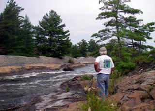
We met several boats while we were there, joined them on several "safaris" and had cocktail parties and potlucks on the rocks. We explored the Jameson River up to the rapids. We thought we were told that you could go up the Little Jameson rapids, right hand channel, but, no, too many rocks. We stopped on the island between the Big Jameson rapids and the Little Jameson rapids, and right hand rapids and while we were picking blueberries, saw a boat go down the Big Jameson rapids, no rocks. Aha, away we went, got up on plane and headed for the rapids. We made it! After getting up the rapids we explored several channels but kept running into more rapids. We finally went fishing, near Herring Chutes (rapids to narrow and steep to shoot, and caught several smallmouth bass, supper. We later learned that the boat we saw heading down the Jameson Rapids had not gone up the rapids. In the end it did not matter.
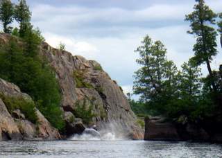 Heart Tug, a boat that anchored near us, said that we could go up the Devil's Door rapids. We followed him and made it up and then we went up another set of rapids and made it into the French River system where we picked blueberries. Later on we returned and explored even further up the river but nothing exciting but a lot of fishermen. We kept going up and down the rapids. Craig was having way too much fun. Lovers Lane Crooked Rapids taking us upstream to the French River system and Lilley Rapids taking us downstream were one-way rapids. There was a Do Not Enter sign at the top of the upstream rapids.
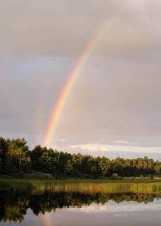
We also explored the Bad River out to the bay and found a lot of rocks and passages between them. You could spend all summer here exploring but we had to move on. Gerry and Maren from Dragonfly dinghied over from the Bustards and were going to do the rapids with us but a storm was brewing so they headed back after only an hour or so. We met them last year in Little Current. We did weather a couple of major storms here (in one day) -- At 16:00 it was as dark as dusk and you could see the storm coming. We also met the granddaughter, from Heart Tug, of a man who once had a cabin in the Jameson River just below the first rapids we encountered. It was interesting to hear some of the history of the area. Day did print out information on rattlesnake bites as rattlesnakes and bears are very abundant in the area. She made more noise than usual.
August 11, 2008 -- Bad River to Dufois Bay
 When you get a little bit overconfident the rocks have a way of knocking you back down. On the way out of Bad River, we went up on a rock and stopped. We futzed and fumed and reversed and went forward to no avail. The wing was centered on a rock where we could spin around but couldn't get off. Finally we moved a little and literally fell off of the rock. We were a lot more careful for the remainder of the trip, at least until we got to clear water. The gods smiled and we had a great sail for the rest of the day's journey to Dufois Bay.
Dufois Bay is a small little bay near to Killarney. We were a little worn out with all the socializing in Bad River so the solitude was welcome. Only one boat joined us the first day and we were alone the second day.
August 17, 2008 -- Port of Little Current town docks
 A day for laundry and shopping and visiting. It's no excuse but we've been coming in to a marina so infrequently that we hardly have time to get on the Internet to update our website or check our Email. By-the-way, you can get free access to the internet from your boat at the Little Current town docks, check with the dock attendants. Of course, you have to be on your boat and have the computer turned on to do it. Something we've had a problem doing.
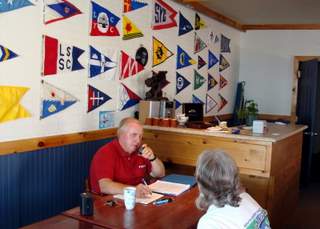
Roy Eaton, from the Cruisers Net, had a potluck dinner at his place Sunday evening to celebrate the 4,000th call-in to the Cruisers Net this year. Seeing as we have a car now in Little Current we drove over, offering a ride to ?????. It was fun renewing old acquaintances and making new friends from the States and Canada. But even up here in Northern Ontario, you can't get away from the Cubs-Sox rivalry, see pictures. Roy has a beautiful house overlooking the North Channel and Picnic Cove (aka Eaton Bay)
August 19, 2008 -- East Rous Island to Logan Bay via Little Current
We thought we might have some mail coming into Little Current post office so we headed to Little Current to check. No mail but we found out we could call the post office to check if we had any mail before coming in. A great advantage if your mode of transportation only does six knots. A customer-friendly quasi governmental entity, amazing. However, postage is expensive in Canada -- $1.05 to mail a one ounce letter. Maybe our rates aren't all that bad.
Leaving Little Current with the post office's phone number in our char book, we headed west on a nice beam reach sail. When we got to the Waubuno Channel, we thought about heading north but the wind would be on the nose as we were cruisers with no definite destination, we continued west to Clapperton Island and headed northwest. With the winds were getting lighter, we stopped at Logan Bay on the east side of Clapperton.
Logan Bay is a large anchorage with a clay bottom. The scenery is not that spectacular but it is a good stopping point and nobody was there. We didn't do much. We just relaxed from our strenuous activities in Little Current.
August 20, 2008 -- Logan Bay to Hotham Island, West Harbour in Oak Bay
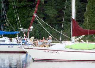
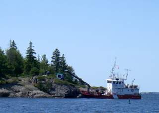 We have a destination! We had talked to Karel and Mila from Quintessence and had decided to meet in Oak Bay (AKA West Harbour and Hotham Island and even The Retirement Home). We sailed out of Logan Bay north to the Main Passage between Clapperton Island and the Benjamin Islands. The winds turned fluky but we had a destination so we tacked our way west until we could get to the passage between Eagle Island and the Benjamins. The winds were still fluky but we persevered until we turned west between Fréchette and Eagle Islands. Enough was enough and we powered past a Coat Guard vessel fixing the wind damaged buoys in the McBean Channel and entered Oak Bay.
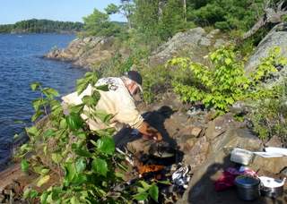
It was good to be back in one our favorite harbors. Quintessence was there and we renewed our friendship over a couple liters of red wine and some fresh bass cooked over a fire. Karel is renowned as a fisherman and had caught a mess of bass and invited us to dinner. Karel found a spot on shore to build a fire, to cook the bass and potatoes and serve dinner. What a feast!
August 21, 2008 -- Oak Bay to Moiles Harbour
We were still heading west and tried to sail but after awhile it got so light that we had to motor. We motored through Little Detroit, the narrow passage between Aird Island and Black Fly Point (!), past Passage Island and tiring of it motored into Moiles Harbour and dropped the anchor.
 Moiles Harbour is a former harbor for the Moiles brothers sawmill. There are the remains of old wharfs, many deadheads and a lot of sawdust mixed up with the mud creating iffy holding. We still like the picturesque harbor and usually have no problems setting the anchor. The clustering effect accorded once more when a boat came in and, even though there was plenty of room elsewhere, anchored so close to Quintessence that when the wind shifted in the middle of the night, they had to move to avoid hitting Quintessence.
August 22, 2008 -- Moiles Harbour to Long Point Cove
In the morning, when we left, we hit a deadhead. It shook the boat but no problem. Once out in the Whalesback Channel we had some wind. We sailed from Moiles all the way to the Entrance to Long Point Cove. Taking a shortcut between an unnamed island and Knight Point -- narrow passage but downwind it was manageable. The entrance is between some islands with a few rocks inconveniently spread around. Quintessence was there already with a few other boats but nothing like it was last year when we were there earlier in the season.
It's fairly easy to anchor but it is a small anchorage and you do have to watch out for other boats that were there first. On our second try we got a spot that we were happy with.
August 23 - 24, 2008 -- Long Point Cove
 We decided to explore the area by dinghy and also take a look at the North Channel Yacht Club. We had visited the club back in the 80's on our first trip to the North Channel and we were curious as to any changes. We motored by the club and up the Serpent River as far as we could go (where the railroad crosses the river and there are some shallow rapids). On our way back we noticed some black clouds heading our way. Near the KOA campground, a guy splitting wood yelled out that we were going to get wet. We hadn't brought along any rain gear and being comfort oriented, we put the dinghy on plane and roared down the river hoping to get back to Toucan before the storm hit. We saw that we wouldn't make it when we were about to the club and altered course to try to get into the club before it hit. We had just made it to the edge of the mooring field when the bottom fell out of the sky, wind and horizontal rain that hurt. By the time we got to shore we were thoroughly drenched and sought shelter in a phone booth (Canada still has them). The booth being a little small we found a slightly bigger shelter nearby the slips.
Our luck changed when two members, who were out fishing in the storm, saw us and invited us up to the clubhouse. They turned on the lights, started a fire and made coffee, offering us cups that also had a little, much appreciated rum in them. More members drifted in and we didn't leave for a couple hours, not quite dry but, after more than a few rum and coffees, quite happy.
Our next concern was how Toucan rode out the squall line (yes there was a warning issued by the weather guys -- after we were in the club by the fire and the storm had passed an hour before). We knew Karel was near Toucan and would do take care of Toucan if something happened, but you still worry about an unattended boat at anchor in a storm. Turned out that Toucan rode out the storm better than we did with the only problem being a little water on Day's side of the bed (we didn't close the aft hatches enough).
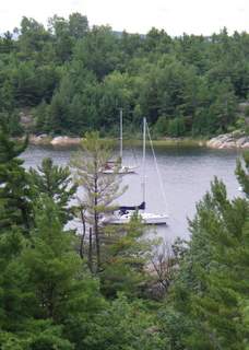
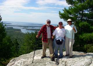
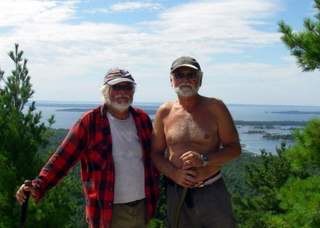
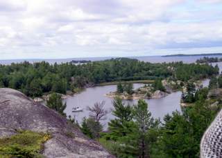 The next day we went hiking. One of the reasons that Karel and Mila wanted to go to Long Point Cove was that they had heard that there were some interesting hiking trails there or nearby. They couldn't find any trails per se (but there are a lot of rocks to climb). Later in the day, a couple came by and said that they were going to take a trail up the rocks on the north side of the entrance to the cove. We went along and it was well worth the walk/climb (take a look at the pictures).
August 28, 2008 -- Oak Bay
Karel wanted to see if we could find a trail to the top of Mt. McBean. We dinghied over McBean Harbour and Mila asked if there was a trail and if we could hike it. The trail is on Sagamok First Nation lands. She found where the trail was and away we went. The trail was verrry interesting but beautiful and the view from the top made it all worth while. We were able to reach Blue Heron at the Little Current town docks on our small VHF hand held radio.
When we got back we found that Blue Heron and Fairy Tale (AKA Trillion V) had showed up and anchored nearby. After cocktails we stayed on Blue Heron, had dinner and discussed their heading back to Michigan (Torresens) to try to sell Blue Heron and buy a POWER BOAT! A very pleasant evening reliving past experiences and discussing the future.
August 31, 2008 -- Browning Cove
We did nothing but try to catch up on all the stuff we hadn't done during the summer. It's amazing but we always seem to busy and never get the needling little details done. I guess the leisure time activities of exploring, socializing, hiking, fishing, socializing sailing, anchoring, socializing, eating take time.
 We decided to stay another day and do our laundry and some grocery shopping. Once Day finished the laundry at the marina, we borrowed the marina's van and drove into town to do our grocery shopping (and touring). Groceries were expensive and sparse so we only got the necessities, beer and bread and a couple of other items. We noticed that you can go the grocery store and post office (which was closed) from the marina by dingy so we tried it. You have to go up Magnetawan River past most of Britt and then go up this little river to the "city docks". We also explored the Magnetawan River all the up to the road that goes from Sudbury to Toronto. We did find another grocery store that was closer and had staples a little cheaper but no beer so not as popular.
 We decided that since Killarney was so close we would dinghy over to do our grocery shopping, stop at the post office for stamps and have fish and chips at the "fish bus", an obligatory stop if you're in Killarney. The fish and chips were great as always but the groceries were really expensive, even for this part of Canada. All we got were eggs and a fun dinghy trip. Killarney is set up for cruisers passing through -- short term tie-ups at the LCBO (liquor store), the grocery store and of course the fish bus. There was a man who was working on a dock near where we anchored but he was only there for an hour or so.
 There was no wind when we left so we motored down the south leg of the small craft route south of Badgeley Island turning north at Partridge Island to Frazer Bay. We were considering going to Blueberry Island but tired of motoring, so we stopped at Boyle Cove. The bay is not protected from the north but even though the winds were forecast to be from the north, they were forecast to be light. The bay is deep so we tried to anchor close to shore in 20 to 25 feet of water with 120+ feet of rode but we were almost too close. In a thunderstorm that came through, we swung quite close to shore but no problem.
 Day made some more bread and cinnamon rolls in the morning. In the afternoon, we got in the dinghy and toured Frazer Bay with a wary eye on the weather. We went ashore by some rocks and tried to find some blueberries but while we found a lot of plants, something ate them all up. We also found a cave with a lot of fresh scat. A coincidence, maybe? Thankfully, he wasn't home. We saw a beaver here and heard loons.
 Many people who come up to the North Channel from the States talk about stopping at Beardrop Harbour on their way east through the Whaleback. Quintessence was heading back to Eagle Island but we decided to stop at Beardrop to see what it was like.